Image Processing Methods for Coronal Hole Segmentation, Matching, and Map Classification
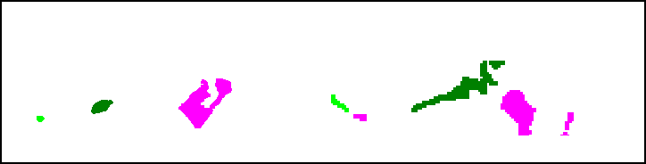
Abstract: The paper presents the results from a multi-year effort to develop and validate image processing methods for selecting the best physical models based on solar image observations. The approach consists of selecting the physical models based on their agreement with coronal holes extracted from the images. Ultimately, the goal is to use physical models to predict geomagnetic storms. We decompose the problem into three subproblems: (i) coronal hole segmentation based on physical constraints, (ii) matching clusters of coronal holes between different maps, and (iii) physical map classification. For segmenting coronal holes, we develop a multi-modal method that uses segmentation maps from three different methods to initialize a level-set method that evolves the initial coronal hole segmentation to the magnetic boundary. Then, we introduce a new method based on Linear Programming for matching clusters of coronal holes. The final matching is then performed using Random Forests. The methods were carefully validated using consensus maps derived from multiple readers, manual clustering, manual map classification, and method validation for 50 maps. The proposed multi-modal segmentation method significantly outperformed SegNet, U-net, Henney-Harvey, and FCN by providing accurate boundary detection. Overall, the method gave a 95.5% map classification accuracy.
Paper Prompts
Sign up for free to create and run prompts on this paper using GPT-5.
Top Community Prompts
Practical Applications
Immediate Applications
The following bullet points summarize practical use cases that can be deployed now, leveraging the paper’s multimodal segmentation, spherical cluster matching via Linear Programming, and Random Forest–based map classification. Each entry notes sectors, potential tools/workflows, and key assumptions or dependencies.
- Coronal hole–driven model selection for operational space-weather forecasting (sectors: aerospace, energy, telecommunications)
- What to do: Integrate the segmentation–matching–classification pipeline to select the best daily coronal hole map among candidate PFSS/WSA runs for downstream solar wind and geomagnetic storm forecasts.
- Tools/products/workflows: “Coronal Hole Model Selector” module; workflow = ingest EUV + magnetograms → multimodal union segmentation (Henney-Harvey, SegNet, FCN) → level-set evolution constrained by magnetic neutrality → spherical cluster matching via LP → Random Forest classification → handoff to WSA/ENLIL for propagation.
- Assumptions/dependencies: Timely access to EUV (e.g., STEREO/EUVI, SDO/AIA) and photospheric magnetic maps (e.g., SDO/HMI); synchronization between observation and model timestamps; integration into existing WSA operational pipelines; robustness across instrument calibrations and coverage gaps (black pixels).
- Decision support for satellite operations (sectors: aerospace, telecommunications)
- What to do: Use improved selection of physical maps (95.5% map classification accuracy reported) to refine lead times and confidence for high-speed solar wind stream arrivals; schedule safe modes and maneuver windows.
- Tools/products/workflows: Ops dashboard fed by model-selection outputs and downstream Kp/Dst forecasts; alerting thresholds tied to matched coronal hole cluster characteristics (area, latitude).
- Assumptions/dependencies: Reliable mapping from selected coronal hole maps to geomagnetic indices; operational latency compatible with daily planning; continuity across the solar cycle.
- Grid reliability adjustments (sectors: energy/utilities)
- What to do: Incorporate model-selected forecasts into day-ahead mitigation (e.g., re-dispatch, transformer loading limits, dynamic line rating) for expected geomagnetic disturbances.
- Tools/products/workflows: API feed from forecasting center with confidence scores derived from matching/classification; integration with EMS/DMS tools.
- Assumptions/dependencies: Established conversion from space-weather forecast products (e.g., WSA-ENLIL outputs) to actionable grid risk metrics; coordination with national centers (e.g., NOAA SWPC).
- Aviation HF communications and polar route planning (sectors: aviation, telecom)
- What to do: Adjust HF comms planning and polar overflight schedules based on coronal hole–driven risk windows (e.g., polar cap absorption likelihood) inferred from selected model maps.
- Tools/products/workflows: “HF Risk Index” derived from coronal hole area/latitude and historical empirical models.
- Assumptions/dependencies: Empirical coupling between coronal hole properties and ionospheric absorption; integration with ICAO/FAA advisory systems.
- GNSS/precision positioning service advisories (sectors: navigation, surveying)
- What to do: Issue enhanced ionospheric correction advisories during forecasted high-speed streams; preemptively adjust receiver settings or scheduling of critical measurements.
- Tools/products/workflows: Service advisories keyed to selected physical maps and propagation models.
- Assumptions/dependencies: Established pipelines from space-weather operations to GNSS corrections; regional tailoring.
- Ground-truth standardization and reproducibility in solar image research (sectors: academia, government labs)
- What to do: Adopt the paper’s consensus-map, clustering, and matching protocols to reduce inter- and intra-rater variability in dataset creation and benchmarking.
- Tools/products/workflows: “Consensus Map Builder” and “Cluster Matching Protocol” SOPs; training materials; dataset curation.
- Assumptions/dependencies: Availability of trained annotators and protocol compliance; dissemination of datasets and code.
- Boundary-aware level-set segmentation library for solar images (sectors: software/ML, academia)
- What to do: Apply the DRLSE-based level-set method with magnetic-neutral-line constraints to achieve pixel-accurate coronal hole boundaries, especially where CNNs underperform at edges.
- Tools/products/workflows: “Boundary-Constrained Level-Set” Python/MATLAB module with EUV+magnetic inputs.
- Assumptions/dependencies: Access to magnetic maps; parameter optimization (α, σ) via pattern search; adequate compute (GPUs optional for NN initialization, CPUs sufficient for level sets).
- Classification-driven QA for physical model outputs (sectors: research ops, forecasting centers)
- What to do: Use Random Forest classification of matched/new/missing coronal hole clusters as a quality gate to accept/reject model maps before operational use.
- Tools/products/workflows: Automated rank grouping and acceptance tests; audit trail of decisions.
- Assumptions/dependencies: Retraining with local data distributions; monitoring drift across solar cycle phases.
- Educational modules and hands-on labs (sectors: education)
- What to do: Build coursework around multimodal segmentation, spherical geometry matching, and model-selection, demonstrating end-to-end scientific ML in heliophysics.
- Tools/products/workflows: Lab notebooks; prepackaged datasets and reference implementations.
- Assumptions/dependencies: Open educational licenses; simplified compute environments.
- Insurance and finance risk analytics for space-weather–exposed sectors (sectors: insurance, finance)
- What to do: Incorporate improved forecast reliability into underwriting and risk models for satellite operations and telecom services.
- Tools/products/workflows: Risk dashboards integrating forecast confidence scores from the classification stage.
- Assumptions/dependencies: Actuarial models that translate forecast skill improvements into risk premiums; access to historical outcomes.
Long-Term Applications
The following opportunities need further research, scaling, model integration, or policy development before broad deployment.
- Auto-tuning of PFSS/MHD model parameters via data-driven matching (sectors: software, research ops)
- What to do: Use cluster matching outcomes to estimate and adjust PFSS source-surface radius or MHD heating parameters, closing the loop between observations and physical models.
- Tools/products/workflows: “Auto-tuned PFSS Parameter Estimator” feeding daily runs; iterative assimilation framework.
- Assumptions/dependencies: Stable mapping from matching metrics to optimal parameters; validation across diverse solar conditions; robust optimization in production.
- End-to-end real-time operational pipeline across instruments and solar cycle (sectors: government labs, forecasting centers)
- What to do: Scale the pipeline to continuous, multi-instrument operations with fault tolerance, cross-calibration, and latency guarantees.
- Tools/products/workflows: Distributed microservices; data harmonization for EUV/magnetograms; monitoring and model governance.
- Assumptions/dependencies: Sustained funding; resilient access to multiple spacecraft data streams; harmonized calibration standards.
- Integration with 3D MHD models and solar wind propagation (WSA-ENLIL, CORHEL) for improved storm onset timing (sectors: aerospace, energy)
- What to do: Extend model selection beyond PFSS to include MHD runs; propagate selected maps to Earth with uncertainty bounds.
- Tools/products/workflows: “Multi-model Selector” spanning PFSS/MHD; probabilistic forecast products (Kp/Dst distributions).
- Assumptions/dependencies: Access to MHD runs; compute resources; comprehensive validation campaign.
- Probabilistic forecasting and uncertainty quantification (sectors: policy, operations)
- What to do: Translate classifier confidence/score distributions and Bayesian segmentation uncertainty into probabilistic advisories for decision-makers.
- Tools/products/workflows: Calibrated likelihood models; decision thresholds aligned with operational risk tolerance.
- Assumptions/dependencies: Statistical calibration and reliability analysis; user training on probabilistic products.
- Extension of spherical LP-based matching to other planetary/earth sciences (sectors: Earth observation, planetary science)
- What to do: Apply the matching framework to features on spherical surfaces (e.g., ozone holes, polar sea-ice openings, planetary auroral features).
- Tools/products/workflows: Domain-specific adaptations of spherical geometry and constraint sets.
- Assumptions/dependencies: Availability of analogous physical constraints; bespoke feature extraction.
- Detection and modeling of additional solar features and dynamics (sectors: heliophysics research)
- What to do: Expand segmentation to streamers, coronal bright points, and CME precursors; improve causal chains to space-weather impacts.
- Tools/products/workflows: New training datasets and feature-specific level-set constraints; multi-feature model selection.
- Assumptions/dependencies: High-quality labeled data; interdisciplinary model integration.
- Autonomous instrument scheduling and adaptive observation (sectors: space mission operations)
- What to do: Use forecast outputs to steer instrument pointing/scheduling (e.g., increased cadence over evolving coronal holes).
- Tools/products/workflows: Closed-loop scheduling agents; priority queues tied to forecast confidence.
- Assumptions/dependencies: Mission autonomy frameworks; ops acceptance of algorithmic scheduling.
- Standards and regulatory frameworks for space-weather advisories (sectors: policy, aviation)
- What to do: Codify coronal hole–based metrics into ICAO/FAA advisory standards; define minimum performance and validation requirements for operational products.
- Tools/products/workflows: Policy guidelines; certification protocols; shared validation datasets.
- Assumptions/dependencies: Multi-agency consensus; documented performance across solar cycles.
- Economic impact modeling for society-scale planning (sectors: public policy, finance)
- What to do: Couple improved forecasts to macroeconomic models of disruptions (satellite, grid, aviation) to inform resilience investments.
- Tools/products/workflows: Integrated assessment models using forecast skill improvements and event rates.
- Assumptions/dependencies: Data-sharing agreements; rigorous post-event attribution.
- Citizen-facing space-weather applications (sectors: consumer software)
- What to do: Build apps that translate forecast improvements into actionable guidance for ham-radio operators, pilots, and high-latitude communities.
- Tools/products/workflows: Personalized risk indices; notification systems; educational content.
- Assumptions/dependencies: Reliable public APIs; user adoption; clear benefit communication.
In all cases, feasibility depends on the availability and quality of EUV and magnetic data, proper temporal alignment, robust cross-instrument calibration, computational resources for both NN initialization and level-set evolution, and validated mappings from selected physical maps to downstream geomagnetic indices and sector-specific risk metrics.
Collections
Sign up for free to add this paper to one or more collections.

