- The paper introduces a modified DeepLabV3+ architecture with a Dilated ResNet backbone that accurately extracts building footprints from RGB satellite imagery.
- It incorporates the F-Beta measure and exponential weighted boundary loss to mitigate class imbalance and enhance boundary delineation.
- Results on Urban3D, SpaceNet, and AICrowd demonstrate state-of-the-art accuracy, offering practical benefits for urban planning and policy-making.
Introduction
The paper "A Semantic Segmentation Network for Urban-Scale Building Footprint Extraction Using RGB Satellite Imagery" (2104.01263) addresses the problem of extracting building footprints from RGB satellite imagery using deep learning techniques. This task is critical for urban planning, energy management, and climate policy, yet it remains challenging due to issues of scale invariance and class imbalance in data. Previous methods often rely on additional costly data such as point clouds or multi-band imagery. The authors propose a novel approach using a modified DeepLabV3+ network with a Dilated ResNet backbone, capable of producing accurate building footprints using only RGB imagery. The method introduces the F-Beta measure within its objective function to handle class imbalances and leverages an exponentially weighted boundary loss for increased accuracy in delineating building edges.
Methodology
The methodology hinges on a revised DeepLabV3+ architecture with crucial modifications:
- Network Architecture: The standard U-Net model is replaced by DeepLabV3+ utilizing a Dilated ResNet backbone. This configuration exploits dilated convolutions to capture finer details with larger receptive fields, crucial for distinguishing buildings from their backgrounds in lower-resolution images.
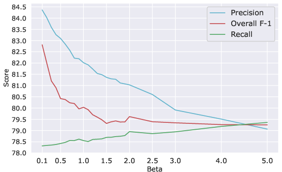
- F-Beta Measure: Introduced as part of the objective function, this measure enables the network to focus on either precision or recall during segmentation, using a tunable parameter β. Tuning β is essential for managing false positives prevalent in building segmentation tasks.
- Exponential Weighted Boundary Loss (EWC): This loss function applies a high penalty on boundary mispredictions to improve the network's ability to distinguish between closely situated buildings. Weight maps guide the network in identifying separate entities where buildings are densely packed.
- Cross-Dataset Training: To strengthen the generalization capabilities, a cross-dataset training approach employs samples from various datasets. This strategy enhances the network's adaptability to different scales and densities present in satellite images from different urban areas.
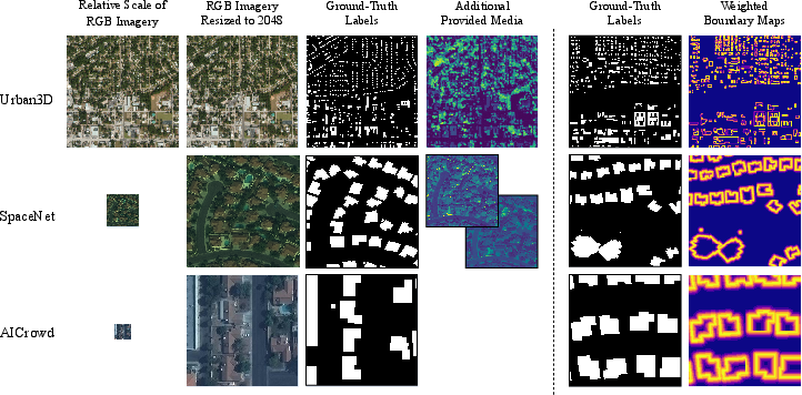
Figure 1: Visualizations of samples from each dataset used in this paper, depicting the breadth of geographic and density variations.
The proposed architecture achieved state-of-the-art results across three benchmark datasets: Urban3D, SpaceNet, and AICrowd. It outperformed several existing models, including U-Net Ensembles and Mask-RCNNs, demonstrating superior precision and recall, particularly in densely populated urban regions.
Key Results:
Implications and Future Work
The research provides compelling implications for urban modeling applications. By reducing reliance on supplementary data, the method expands applicability to regions where only basic RGB imagery is accessible, democratizing access to advanced urban planning tools.
From a theoretical perspective, the introduction of the F-Beta measure could influence the design of loss functions in other segmentation tasks confronted with class imbalance issues. Practically, refining segmentation accuracy can directly inform municipal decision-makers and accelerate urban energy models, potentially influencing policy and strategic urban development.
Future developments could explore further optimizing the β parameter across diverse datasets to achieve more adaptive network performances or integrating this method with real-time satellite data feeds for up-to-date urban footprint extraction.
Conclusion
The paper advocates a robust method for building footprint extraction using RGB satellite images, minimizing dependencies on costly supplementary datasets. By leveraging advanced architectural design and a novel objective function, the authors significantly advance the state-of-the-art in building segmentation tasks, offering practical solutions for urban planners and policy-makers engaged in energy and climate initiatives.
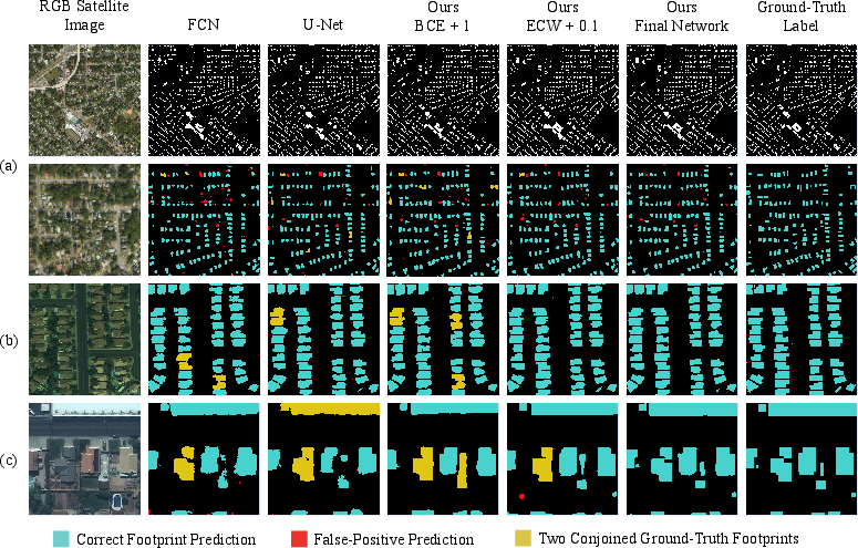
Figure 3: Visualizations of predictions from all datasets by four variants of the proposed method and two baselines, highlighting qualitative improvements.